


וְאַחַ֤ר הָרַ֙עַשׁ֙ אֵ֔שׁ לֹ֥א בָאֵ֖שׁ יְהוָ֑ה וְאַחַ֣ר הָאֵ֔שׁ קֹ֖ול דְּמָמָ֥ה דַקָּֽה׃
And after the earthquake, a fire--the Eternal
was not in the fire. And after the fire--kol
ramamah dakah--a soft murmuring voice.
-- I Kings 19:12
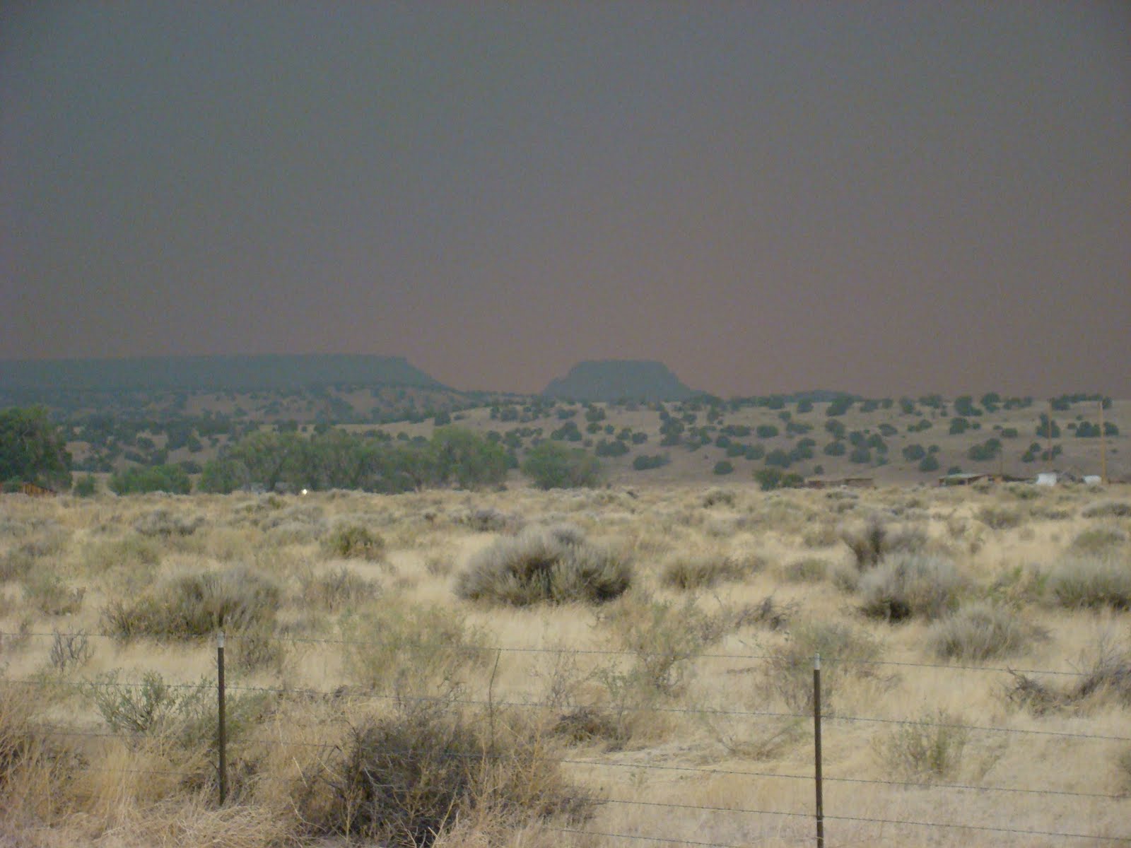
 Over the past week we have had the opportunity to drive roads that were closed a week or two ago, through the Apache-Sitgreaves and in the Rim Country, on Monday, down to Luna and today over to Pinetop-Lakeside. Each time, as we drove across the state line, we saw the shadow on Escudillo Mountain, the burned areas coming down near to Eager itself. We saw the blackened places along US 180 and SR 260, where backfires had been set. But we also saw the damp ground where the monsoon rains had brought out the green of new growth. And near the Fort Apache ski area, we saw the ferns under the jack pines, impossibly green where a month ago there was only brown. Deer crossed the highway, taking their own sweet time, and wild horses were grazing again near the lakes and rivers between the Greer turnoff and McNary.
The fire was terribly hard on some of our friends and neighbors, some losing their homes and everything but what they could take out, but many lost only their refrigerators full of food when the electricity went out while they were evacuated. We discovered this when we went into Lowe's at Show Low today to find a fitting for the ice maker/water line we were installing for our refrigerator. Lowe's was out of refrigerator water line fittings. They were low on refrigerators. They had been selling them off the floor to people who needed them. People from Nutrioso, from Alpine, from Greer and Sunrise. The insurance companies were paying Lowe's to lock and haul off the old refrigerators with spoiled food within, and install new ones. And Lowe's was throwing in the new fittings because although the old ones may have been good, when they install they are liable for any new leaks. The kindness of neighbors and the kindness of strangers, and even of large corporations, is a balm to the spirits of those who are now rebuilding homes and lives. We saw each other through, with a little help from friends and strangers.
The fire was terribly hard on some, and very difficult for most here, but the primary response is gratitude. Where ever we have seen burned ridges and valleys, we have also seen the signs. In Nutrioso, in Alpine, in South Fork, in Luna, in Greer: THANK YOU! God Bless Our Firefighters! Thank You, Our Heroes! GREER, ARIZONA: Still Here, Still Green. In case Obama is wondering, this is the fiercely independent, decidedly can-do spirit of Flyover Country, the real America. We do cling to our God and our guns. Proudly. Gratefully. We lift our small voices to the sky.
 And now the monsoon rains have come, on schedule, and they are falling every afternoon over the White Mountains, from the Rim to Escudillo, just as they do most years across the southwest beginning on the 4th of July. Waters are moving over the burned scars, and in the unburned forest still here, still green. The waters trickle, drop upon drop, they beat a steady rhythm on the metal roof at Freedom Ridge Ranch. The winds blow cool air and soft clouds where once it was all fire and smoke and ashes. And we have seen rainbows, double and triple, arching across the mesas and canyons. Promises that life returns with the water.
And after the fire . . . kol rammamah dakah. A soft murmuring voice.
Picture Credits: Top--National Forest Service InciWeb. Middle--Apache-Sitgreaves National Forest Web Page. Bottom: Rain over Escudillo, taken August 2010, Ragamuffin Studies.
And after the earthquake, a fire--the Eternal
was not in the fire. And after the fire--kol
ramamah dakah--a soft murmuring voice.
-- I Kings 19:12
The past month has been a very fast ride. During the first week of June, the Wallow fire in the Apache-Sitgreaves National Forest took off, leaping quickly to the northeast, sending its smoke and ash up to our ranch on winds so strong that the fire was spotting up to three miles ahead of the line. That week was surr eal here, as we went about with windows closed, peering through windows at a world gone smoky and eerily, translucently orange and red. Even up in Albuquerque and Tijeras, the smoke was seen and smelled, the funeral pyre of thousands upon thousands of trees covering six states.
We lost a lot of time down here on what has now been formally named Freedom Ridge Ranch, the chickens are late arriving, the garden only got half-in, and will have to be stocked with plants started at nurseries in Show Low and Albuquerque. We spent a day moving the horses down to the Middle Rio Grande Valley and another moving them back. But we did get the house in Tijeras on the market (listing here in case you know somebody . . .) and we are pretty close to being done moving in down here at the ranch. Work here is now proceeding apace, and though catching up to what we envisioned for this summer is highly unlikely, we find ourselves grateful for what could have happened but didn't as we greet a timely monsoon season with fresh appreciation.
 eal here, as we went about with windows closed, peering through windows at a world gone smoky and eerily, translucently orange and red. Even up in Albuquerque and Tijeras, the smoke was seen and smelled, the funeral pyre of thousands upon thousands of trees covering six states.
We lost a lot of time down here on what has now been formally named Freedom Ridge Ranch, the chickens are late arriving, the garden only got half-in, and will have to be stocked with plants started at nurseries in Show Low and Albuquerque. We spent a day moving the horses down to the Middle Rio Grande Valley and another moving them back. But we did get the house in Tijeras on the market (listing here in case you know somebody . . .) and we are pretty close to being done moving in down here at the ranch. Work here is now proceeding apace, and though catching up to what we envisioned for this summer is highly unlikely, we find ourselves grateful for what could have happened but didn't as we greet a timely monsoon season with fresh appreciation.
 Over the past week we have had the opportunity to drive roads that were closed a week or two ago, through the Apache-Sitgreaves and in the Rim Country, on Monday, down to Luna and today over to Pinetop-Lakeside. Each time, as we drove across the state line, we saw the shadow on Escudillo Mountain, the burned areas coming down near to Eager itself. We saw the blackened places along US 180 and SR 260, where backfires had been set. But we also saw the damp ground where the monsoon rains had brought out the green of new growth. And near the Fort Apache ski area, we saw the ferns under the jack pines, impossibly green where a month ago there was only brown. Deer crossed the highway, taking their own sweet time, and wild horses were grazing again near the lakes and rivers between the Greer turnoff and McNary.
 The fire was terribly hard on some of our friends and neighbors, some losing their homes and everything but what they could take out, but many lost only their refrigerators full of food when the electricity went out while they were evacuated. We discovered this when we went into Lowe's at Show Low today to find a fitting for the ice maker/water line we were installing for our refrigerator. Lowe's was out of refrigerator water line fittings. They were low on refrigerators. They had been selling them off the floor to people who needed them. People from Nutrioso, from Alpine, from Greer and Sunrise. The insurance companies were paying Lowe's to lock and haul off the old refrigerators with spoiled food within, and install new ones. And Lowe's was throwing in the new fittings because although the old ones may have been good, when they install they are liable for any new leaks. The kindness of neighbors and the kindness of strangers, and even of large corporations, is a balm to the spirits of those who are now rebuilding homes and lives. We saw each other through, with a little help from friends and strangers.
The fire was terribly hard on some, and very difficult for most here, but the primary response is gratitude. Where ever we have seen burned ridges and valleys, we have also seen the signs. In Nutrioso, in Alpine, in South Fork, in Luna, in Greer: THANK YOU! God Bless Our Firefighters! Thank You, Our Heroes! GREER, ARIZONA: Still Here, Still Green. In case Obama is wondering, this is the fiercely independent, decidedly can-do spirit of Flyover Country, the real America. We do cling to our God and our guns. Proudly. Gratefully. We lift our small voices to the sky.
 And now the monsoon rains have come, on schedule, and they are falling every afternoon over the White Mountains, from the Rim to Escudillo, just as they do most years across the southwest beginning on the 4th of July. Waters are moving over the burned scars, and in the unburned forest still here, still green. The waters trickle, drop upon drop, they beat a steady rhythm on the metal roof at Freedom Ridge Ranch. The winds blow cool air and soft clouds where once it was all fire and smoke and ashes. And we have seen rainbows, double and triple, arching across the mesas and canyons. Promises that life returns with the water.
And after the fire . . . kol rammamah dakah. A soft murmuring voice.
Picture Credits: Top--National Forest Service InciWeb. Middle--Apache-Sitgreaves National Forest Web Page. Bottom: Rain over Escudillo, taken August 2010, Ragamuffin Studies.


