

Showing posts with label Nearly Wordless Wednesday. Show all posts

Wednesday, June 1, 2011

Road Trip Reserve: A Geology Field Trip

Nearly Wordless Wednesday

Life is getting serious again. There are wars and rumors of wars, the economy is unstable, and some of my readers want a break from "all that." And it just so happens that last week, I took a day trip to the Catron County Seat, the town of Reserve, in order file a deed at the couthouse, on to Luna on the Arizona Border, and back through Reserve to Quemado. I drove from Quemado, and it is a spectacular drive across mountains, mesas, canyons, and two different watersheds. So, it's time for another geology road trip! Because, despite our troubles, the mountains have been standing for more than 40 million years, they are still standing, and will remain long after we--and our troubles--are gone!


Castle Rock as seen in the early morning, along New Mexico State Road 32. Like many of the mesas in the Mogollon-Datil Volcanic fields, it is a remnant of a Tertiary Conglomerate (the O.K. Bar Conglomerate) preserved by a cap of Quaternary Basalts, that has slowed its weathering. The basalts are very young, extruded less than 2 million years ago. Castle Rock is in the Apache National Forest, in the Largo Creek Wash--in the Little Colorado Watershed.


Further south on S.R. 32, the road plunges over the edge of Jewett Mesa, and into the Apache Creek Canyon. A divide had been crossed, and Apache Creek is part of the San Francisco Watershed. The water that falls on the southern reaches of Jewett Mesa flows into the San Francisco River, then into the Gila, and finally to the Colorado and the Gulf of California. The lava rocks in the center, right of the trees is made up of Tertiary Andesites that are much older than the basalts on Castle Rock. They were extruded more than 37 m.y.a.


South, after plunging into Apache Canyon, the road rides upon Tertiary-Quaternary alluvium of the Gila Conglomerates, and winds along Apache Creek into the small town of Apache Creek, at the junction of Route 32 with New Mexico 12. Apache Creek also sits at the confluence of Apache Creek with the Tularosa River, flowing southwest from its source in a small canyon on Tularosa Mountain. The camera here was pointed north across wetlands at the confluence, looking toward Jon South Mountain.


From Apache Creek, S.R. 12 winds southwest along the Tularosa to Cruzville, and then leaving the river, crosses the faults of the San Francisco Mountains, riding now on Tertiary Ash Flow Tuffs, and again on Quaternary Basalts. Here, looking west of the road across the Gila Formation, we see Mess Box Canyon, composed of a gate of Quaternary Basalts, and framed by older Tertiary Rhyolites and Andesitic domes that make up Higgins Peak and Monument Mountain.


The town of Reserve sits on a mesa at the north end of the Saliz Mountains, and in the Valley of the San Francisco River, that winds through the canyons from Arizona into Luna, and on into the Catron County Seat. Just south of Reserve, between Upper and Lower Frisco Plazas, the Tularosa River and Negrito Creek run into the San Francisco, doubling the size of the river.


After leaving Reserve, Route 12 takes a right angle west through the Five Bar Ranch, and joins US 180, which I took northwest to Luna, where I got my rifle a sling at Southwest Shooting authority. To get to Luna Valley, 180 winds across the San Francisco Mountains. Here we see the cross bedding in dune deposit sandstones that lie below the rhyolites and basalts of Prairie Point Peak. The cross-bedding in this sandstone of the Gila Group is spectacular indeed.

Following the visit to Luna, I turned back along US 180, and S.R. 12, through Reserve and back up Apache Creek Canyon, across the divide, and through Jewett Gap toward Quemado.


Noontime in the Largo Creek Wash, the dark green gymnosperms forming the side of Largo Mesa. Here, in the Little Colorado Watershed, the cottonwoods were just beginning to leaf out in a delicate green, only a few weeks past the last frost in this high Mesa and Canyon country. The waters of Largo Creek flow into the Carizzo Wash that flows just south of the Zuni Plateau, and into the Little Colorado River south of Winslow Arizona. The Little Colorado flows into the Colorado at the Grand Canyon, far north of where the Gila waters join it, near Yuma in southern Arizona, on the California border, and just north of Mexico.


Coming into Quemado from the south along S.R. 32, we cross into the more open canyon and mesa country of the Mogollon slope. Here the mesas are high, and one can see for miles. The mesas and peaks here are all part of the Datil-Mogollon volcanic field, composed of Tertiary and Quaternary volcanics, with a Chain of Craters that march north and east, from the Red Hill near the Arizona border to Mount Taylor. The youngest of the lavas are less than 2,000 years old north in the Malpais. The earth is still very active in this part of New Mexico.

Ragamuffin Ranch lies in this open mesa and canyon country, the canyons created by ephemeral washes that lie above shallow aquifers, creating little areas where the grass is good, and the volcanic sediments create a fertile soil watered by wells pumped by windmills.

Wednesday, March 2, 2011

Baby Siete


NEARLY WORDLESS WEDNESDAY


While we were completing the move of our furniture down to Ragamuffin Ranch, admidst the multiple trips back and forth, Lucy the Longhorn kicked her heifer off and disappeared. On Wednesday evening the 16th, I drove down to the ranch, and on Thursday morning as I prepared to drive the truck back up with the Engineering Geek, I noticed that Lucy was not with the herd. She had been looking wide across the hips for the past weeks, and I suspected that she was off calving. The CIT called Thursday night to tell us that he had seen Lucy come to the stock tank to drink and then hurry off again. He thought she was hiding a calf. Later he called to tell us he saw her with the calf near the dirt tank, but Lucy was in no mood to let him get close--she had a little male. For the first week or so, we saw little of Lucy and less of the calf, but lately he has been gamboling along with herd, trying to graze, playing, and checking out this new world of Ragamuffin Ranch. We call him Siete, because after Chuckwagon went from steer to meat, we had six cattle, making Siete the 7th again.


Not at all camera shy, Siete looks toward me from across the fence, trying to puzzle out what this strange person is doing. Mamma Lucy was less pleased, and I used the telephoto lens.


During the mid-afternoon the cattle settle in to chew their cuds after grazing all morning and getting a drink at the nearby stock tank. Siete rests too, here under the watchful eye of his sister, the heifer Blanche (not pictured). Blanche got up and faced me, her half-Brahma features looking remarkably fierce and she stared me and the camera down.


Here, Siete is checking out something of interest to a little boy calf under the juniper, while his mama grazes on the ditch bank. Occasionally he does escape his mother's attention . . .


. . . Siete hurries to near where she is, and when she is close enough, he allows himself to be distracted by his world again.


He's the only baby now, but very soon he will be joined a few others. Freckles is positively lumbering, so great with calf is she, and LB will be calving soon after her.


Spring is coming to Ragamuffin Ranch and so are the baby calves.

Wednesday, February 2, 2011

Nearly Wordless Wednesday: From the Very Edge of the Storm


NEARLY WORDLESS WEDNESDAY REVIVED!


It has been so long since I posted a "Nearly Wordless Wednesday" post on a regular basis that I would have to research my archives to figure out when I was last in the habit. I have been neglecting the fun side and the daily life part of my blog in the past while, but now with a new year and so many changes, it is as good a time as any to revive these homely and fun practices. No better time, really, than when one is at the western edge of an historic blizzard!


Winter Storm Warnings appeared on Sunday here, and were not in effect for Apache County, AZ just 12 miles to the west. The storm formed here, where all the weather maps showed the front forming and the Jet stream was just east of us. The first precipitation started Monday afternoon, in the form of sleet that turned to snow.


It snowed in bands interspersed with sunshine all day Tuesday. Here at the edge, we were getting blowback from the rotation of the storm cell. On Tuesday evening, the dogs and I enjoyed a spirited ball game, the Canine Super Bowl, in weather that was reminiscent of Soldier Field.


It snowed all night Tuesday to Wednesday morning, and the Cross Quarter dawned gray and cloudy, but soon turned to sunshine as the cold front finally rotated back to us. A snow day for the CIT meant that we fed the cattle in the light. Domestic cattle do not scrape off the snow to get at the grass. They must be fed when the snow is on!


The snow in this picture is deeper than it looks--about six inches fell on Ragamuffin ranch.


This snowy hillside is the view from my new office window in the house at Ragamuffin Ranch. It was taken this afternoon, when the storm had passed and the cold had come on.

Although it is quite cold outside, the sun coming through the picture window feels warm on my face.


A combination of fog created by the sublimation of the snow by the intense sunlight and windblown surface snow obscure the side vents of the Red Hill caldera to the northeast, making a kind of foggy ground blizzard in the plains north of our valley. Beautiful. And deadly cold.

I don't know if old Punxatawney Phil saw his shadow or not, but I do hope that we get an early spring this year! Last year it was quite late, and I am still shell shocked from the two-storms per week regimine that we endured last year. I like snow. And we need it. But the bitter cold, I can do without.


Wednesday, July 14, 2010

A Very Cool Milkweed . . .


NEARLY WORDLESS WEDNESDAY
I have put off the 2010 return of One Hundred Species while my camera--the one that took a short dip in the Rio Grande--dried out. Utterly. And Completely. Now, a very cool member of the Asclepidaceae:


#48: Asclepius asperula--common names: Spider Milkweed or Antelope Horn. Like all the milkweeds, this plant is poisonous to animals (including humans), and contains a milky latex. It does attract bees, butterflies and birds, and is primary food for the Monarch Butterfly. Monarch then ingest the bitter milky latex and become bad-tasting to birds.

Wednesday, March 3, 2010

Spring Doesn't Quite Begin in March . . .


NEARLY WORDLESS WEDNESDAY


. . . Or at least, March does not begin with spring. The Purim Full moon happened Sunday night to Monday morning, and with it came another round of snow. This time, light and fluffy.


The full moonset from the bedroom patio, while it was still fair dark . . .


Later, I am barely in time to take a picture of the Adar Moon as it begins to slip behind the snow covered Pinyon and Juniper on Los Pecos Loop during the early morning dog walk.


Although it had snowed, the clouds hiding most of South Mountain in the pre-dawn twilight look like the rain-filled clouds of spring and summer. The snow covering the road is soft and slippery. It is barely below freezing and destined to be gone soon.


A February fog fills the Mountain Valley, even though March has just (barely) begun. The evidence of the changing season is subtly there for us, as we walk the meadow in the early morn.


Clouds lit by the sun that is still below the horizon have the look of spring rains rather than the late winter snow they had brought us.


It has been a long, snowy winter. The snow that came to cover the ground on December 7th melted back, but did not depart and we have had many a storm since then.


We have now had at least partial snow-cover for three months.
But on the new calendar, spring does begin in March. And today it is 50 degrees and the sky is blue, even though there is still a good 4-5 inches on the ground under the trees and in the north lee of the hills. The solar angle is perceptibly higher. Winter's grip must loosen at last, and the warmth will come again.


Wednesday, February 3, 2010

January Moon, February Cross Quarter


NEARLY WORDLESS WEDNESDAY


The January 2010 full moon appears to be the largest of the year, because this moon is the closest to the earth. Mars, in opposition, actually passed by the moon on Friday night, although the appeture of my camera was not large enough to catch it.


Moonset on January 30, 2010.
The moon appeared to be very large,
and the air was very clear. Here the moon
stands over the Sandia Mountain front, just before it slipped behind the mountains and under the western horizon.


Although frontal clouds had begun to come up from the south, indicating stormy weather tomorrow, the rising sun shows pink and orange on South Mountain, and lights up the houses on
Rancho Verde Hill.


February cross-quarter sunrise from the top of Los Pecos in the high meadow. On the Winter Solstice the sun rose about two fingers to the right, and as the Old Calendar spring progresses, the sunrise will appear further to the left on this picture.


One of the delights of living in the mountains is the opportunity to see the sun rise more than once on a single day. The Ground Hog's Day sunrise redux--from a lower point on the road at the lower end of the high mead0w. At the winter solstice, the sun rose straight above the road in this picture.

Although clouds were coming in, the Ground Hog saw his shadow, and by legend this means six more weeks of winter.


Although I saw the sunrise twice-- I said one blessing: ". . . who forms light and creates darkness, who makes wholeness and fashions all things." I am sure to the ancients, the progress of the sunrise appearing further and further north with each passing week must have been an entirely reassuring sight.


Wednesday, January 20, 2010

Winter in Sedillo

NEARLY WORDLESS WEDNESDAY

Winter pictures to make the fireside feel warm . . .


The just past full blue moon of December sets above the Sandia Mountain Front to the west. The sky is rimmed with the pink of approaching dawn.


A freezing fog has set on the leaves of a Rocky
Mountain Juniper. The air was damp and cold,
signalling an approaching snowstorm.


More freezing fog on the Juniper at the top of South Sedillo Ridge. All around, the air is full of the very cold fog.


Restless clouds in a turning sky,
telling of the heavy weather.
The snow fell from the first storm
of three coming through this week.


Snow from the second storm fell this morning, adding layers to the snow from previous storms.

The third storm is coming Friday. We have had snowcover up here on Sedillo since December 7. It looks like we may have it until the cross-quarter day.


By then, I believe I will be ready for spring!


Wednesday, December 23, 2009

Walk Between Storms


NEARLY WORDLESS WEDNESDAY


Last night, we were anticipating snow, but when we went sleep it was clear outside.


But this morning the sun rose over a meadow covered in three inches of new fallen snow.

This is as close to a solstice picture as could be gotten from our location this year, as the past two mornings were cloudy.

There's nothing more beautifully incongruous than a snow covered Cholla cactus. The Pinyon trees behind it hold up the heavy, wet snow.

We welcome snow in our desert mountains, not only for it's beauty but for the moisture that can mean the difference between feast and famine, and freedom from fire next spring and summer.


Home on Winter Break, the Boychick begins our morning walk with the grand-dog Ruby, and the new puppy, Umbrae.

The Engineering Geek waves goodbye in the doorway. By the time we return, he'll have scraped the truck and have left for work.

Ruby seems to be lunging for the camera.


The "big girls", Lily and Shayna, alert to a rabbit in the meadow. Shayna seems to have a special love for snow, and is more excited and alert this morning than usual. Off leash, she cavorts and plays, making me play with her, so that I never get any pictures of the fun.


After a walk in the meadow and the woods, we head back. Looking down the long hill west we see the clouds building and beginning to spill over the Sandia Mountain Front. The next wave of the storm is on the way.


Sure enough, by lunchtime, the cleared car is covered, and the snow is falling heavily and steadily, on our ridge behind.
The clouds darkened and lowered, and we had periods of intense snow, and clouds that played hide-n-seek with the sun all afternoon.


As I write, after dark, it is once again clear. But the next wave is on the way according to the forcast.


Those who celebrate Christmas up her on South Sedillo Ridge will have a white one!


Even those of us who don't so celebrate enjoy the beauty of the snow.


Wednesday, December 9, 2009

Lightning and Thunder Blizzard

NEARLY WORDLESS WEDNESDAY
And another snow day. But this time, a blizzard.
On Monday morning the weather alert went out. Blizzard warning for the East Mountains.
I went to an NMPA strategy session with Dave and Ray at Ray's house just west of Moriarity. When Dave and I drove back toward Edgewood at 3 PM, it began to rain. By the time we were climbing the east side of Sedillo hill it was snow. By the time I got the truck and went to get the Boychick, Highway 14 and Frost Rd. were snowpacked.
A walk with the dogs at 8:00 PM and there were three inches and still snowing. Then it stopped.
But the blizzard had yet to arrive. At 5:30 Tuesday morning we were awakened by two very bright lighting flashes, one after another, followed by thunder. Suddenly, with two dogs now on the bed with us, the wind picked up and the snow began to lash the house. The blizzard had arrived. By 5:55 AM, we got the SchoolReach call: two hour delay. After walking the dogs a very short distance, we got the second call. Full snow day. The roads kept drifting as fast as the crews could clear them.


A strong west wind, gusts up to 60 MPH, blows snow across the meadow. On Monday evening, the trees had been beautifully flocked with snow. The wind removed it.


Almost white-out conditions prevailed a good part of the day. The clouds were as dark as rain clouds, but they were producing snow. It was hard to tell sometimes whether it was snowing or just blowing snow.

More falling and blowing snow as the coulds raced from west to east; moments of sunshine peeking through were followed by more clouds piling over the mountain front. And more falling snow.


Afternoon, and the snow stopped. The sun was still playing coy among the clouds--now out, now hidden.

And I finally got an answer to my question. Were the tracks in the yard other dogs or coyotes? Definitely coyote.

Here is a young one, down by the scrub oak behind the house. Beautiful!

Tomorrow. Two hour delay because the roads are icy. But we should be able to get out of here.

Tell El Nino. Tell Winter: Let up until after the wedding.

Please? With a dusting of snow on top?

Wednesday, November 25, 2009

A Trifle Late, But Nearly Wordless Indeed . . .


NEARLY WORDLESS WEDNESDAY

It is the eve of Thanksgiving, the most American of holidays. One upon which a productive people stops to give thanks for the fruit of its labor. And so, in the midst of baking pies, roasting the turkey, and getting the cranberry sauce to jell in the saucepan, I bring you a very nearly wordless Wednesday.


The Tower at Pheasant Run: the place many delegates called home during the 12 days of the Continental Congress 2009.


Heated discussion at the lectern. All the usual suspects present: L-R: Badnarik (TX) and Tebedo (CO)standing next to the Parlimentarian on the platform. Standing below, L-R: Mann (ID), Dodd (CO) and Cox (AK). The standing delegate with the dark curly hair is Kostrick (NH), famous for being armed at an Obama rally.


Deliberating. We see quite a few of the delegates seated with their state delegations. The tables were arranged according to the order of the States entry into the Union. New Mexico, 47th, was seated in the last row.


Caucusing under the American Revolution II flag. Our patriots are every bit as individualistic, strong-minded and stubborn as were those of the first American Revolution, but we stand upon their shoulders in so many ways nonetheless.


I carry the Zia Flag of the Sovereign State of New Mexico out of the room during the closing ceremonies. Arizona (48), to the left ,is ready to follow.


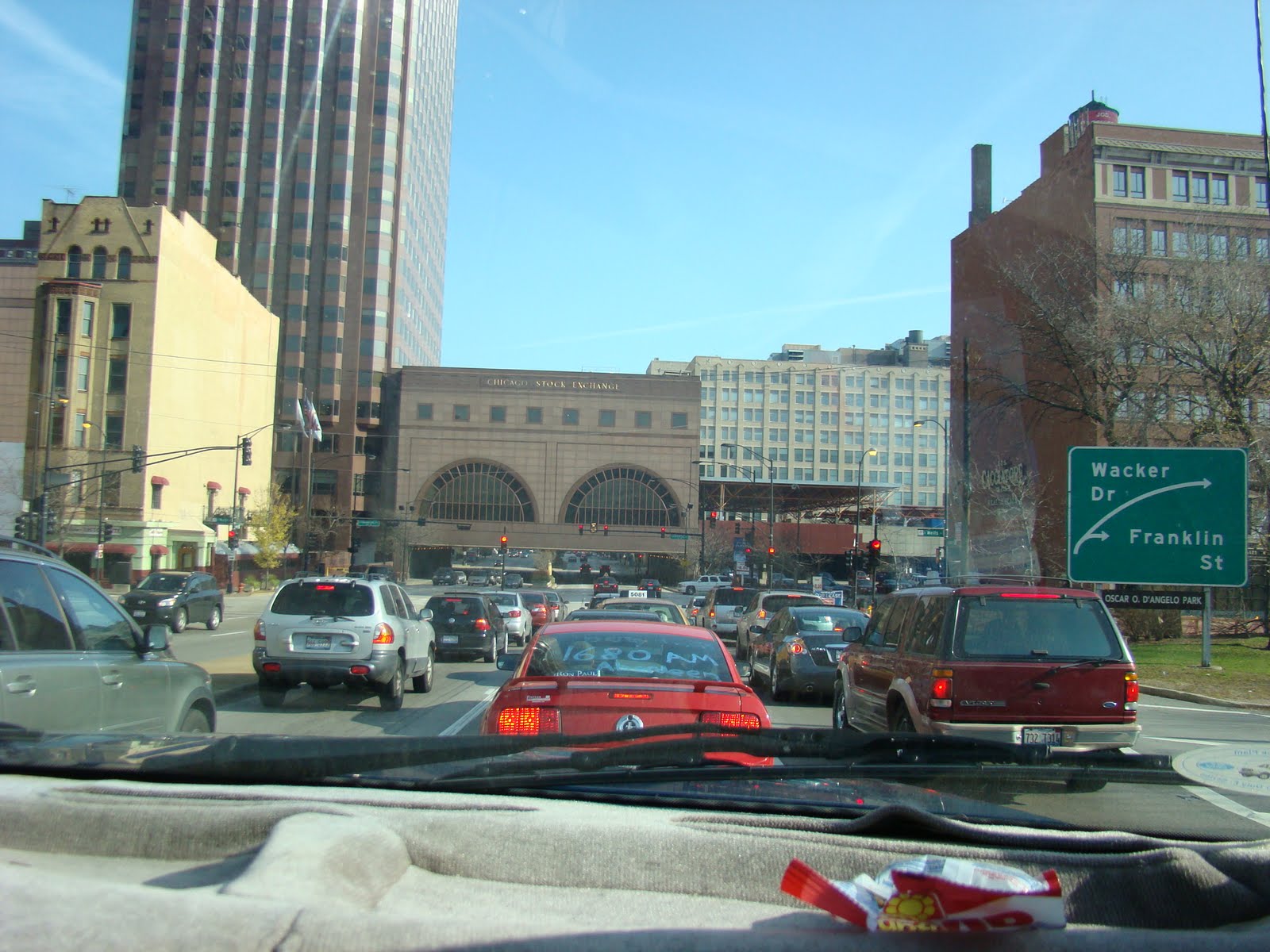
Follow the red car with the Ron Paul bumper sticker in the window! On to the End the Fed Rally! We're at the end of the Dan Ryan Expressway, about to enter Congress Parkway in Chicago. Congress Parkway begins as we drive under the Chicago Stock Exchange building.


Wednesday, November 11, 2009

Going to Continental Congress: Sedillo to St. Charles

NEARLY WORDLESS WEDNESDAY
On Monday, New Mexico Delegate Michael Lunnon and I began the drive from Gallup (in Michael's case) to St. Charles. Michael stopped to get me on a warm and sunny Sedillo fall morning, the kind with the New Mexico blue sky that breaks the heart. We drove 14 hours on Monday, finally stopping in Springfield, Missouri just past midnight Tuesday morning. Yesterday, we drive about eight hours from Springfield, MO to St. Charles, Illinois.
But I still had time to take a few pictures . . .


Looking north just east of Milagro, NM.

Pinyon-juniper woodlands and shortgrass prairie, near the ecotone where, as we descend east, the trees will give way to the grasslands.


At the rest stop west of Santa Rosa, NM, a red-rock canyon composed of brilliant shales, as we descend into the Pecos River Valley.

Rio Grande Valley. Pecos Valley. Later the Canadian. As we go eastward, each river valley will be lower by thousands of feet than the last, as we drive down the incline of the alluvium from the Rockies and Basin and Range.


Grain elevator east of Amarillo on the Texas Panhandle.
We had driven into a frontal system, clouds and fog.


Texas Panhandle, just west of Oklahoma. It seems as flat and level as a table top, and it is indeed one massive mesa. But the slight incline away from the mountains to the west is not perceptible, although it is there. It is the alluvium and wind-blown detritis of the Rockies, fingers of which reach all the way to the Mississippi River.


We drove into the night in Oklahoma, talking and talking, learning to understand each other with respect to all of the issues that will be argued at the Continental Congress. We found ourselves to be sympatico.


In the morning, a water tower in Rolla, Missouri, on the east slopes of the Ozark Dome. Hardwood forests in these low, very old mountains: Maple, Walnut, Oak.


Bare tree on a hilltop west of St. Louis, where the Ozarks are interrupted by the Mississippi River.

They continue into Southern Illinois more weathered still at the edge of the dome; and in Kentucky and Tennessee, meeting the the Appalachians.


Across the 'Father of Waters' (not pictured--we could not pull over), in the coal and oil country of Southern Illinios, we stopped.

The flag is at half-staff to honor the fallen soldiers murdered in Texas. Tomorrow, on Veterans Day, we will renew our oaths to protect and defend the Constitution of the United States.


Woods and pond at a rest stop south of Springfield, Illinois. The clouds were closing in, and we drove through intermittent, heavy rain until it cleared from the west near Joliet, Illinois.

Every time I make this drive, I think about the vastness and diversity of the United States and the uniqueness of the North American Continent.

Stretching from Atlantic to Pacific, the geographic and geological diversity is stunning, as is the regional diversity of the people. An amazing place.

And a fitting way to enter into the frame of mind needed to do our part to restore the Constitution that creates out of that diversity fifty sovereign states, which together create these United States.

E Pluribus Unum. Out of many, one.