


It was a clear, cool and very windy day, with a few puffy clouds over the White Mountains. As we walked across the Safeway Parking lot, dodging wind-blown shopping carts bent on catching the cows in the pasture next door, I watched a hard-bitten character in a black cowboy hat flip a smoking cigarette onto the pavement. He started to walk away, but he must have felt my glare, for he came back and ground out the ember, and tipped his hat. "He could have started a fire!" the CIT hissed when he had passed by, and I replied: "And with this wind, he could have burned down the whole town."
We did our shopping, ate our lunch, and began the drive back across the state line into New Mexico. As the CIT drove, I was watching as a white cloud built to the southwest, over the heart of the Rim Country, and then it seemed that the wind began blowing dust from the clouds toward us. By the time I opened the gate at Ragamuffin Ranch, standing aside to let the CIT drive through, I saw a definite haze clinging to the bottom of our washes and along the ridgelines. "Smoke," I said, having closed the gate and jumped into shotgun position for the drive to Ragamuffin Ranch headquarters.
When we had got the groceries inside, the CIT went to feed the horses, and I turned on my computer. Arizona Fires website had no information yet, but New Mexico Fires had a tweet along the right banner of the page. Following the tweet, I was taken to InciWeb for the Southwest Region, and found out that a small fire had been discovered in the Bear Wallow wilderness of the Apache-Sitgreaves National Forest 18 miles southwest of Alpine, Arizona, which was already a reassuring 50 miles away from us. "No problem," I told the CIT before we sat down to dinner. "It's small, yet, and far away. They'll get it under control before we have to worry about it."
On Wednesday, when I left for Ragamuffin House in Tijeras, the fire was not under control, and we had seen smoke Tuesday evening, but it was still reasonably small and far away. But while I was driving, the Red Flag winds blew that fire up, and overnight that night it grew from 6,000 acres to 40,000 acres. And on Thursday evening, the smoke from the fire blanketed Albuquerque, and was so thick that people wondered if the Bosque was burning again. It was, the radio guy reassured us on the news, the Wallow fire.
I drove back to Ragamu
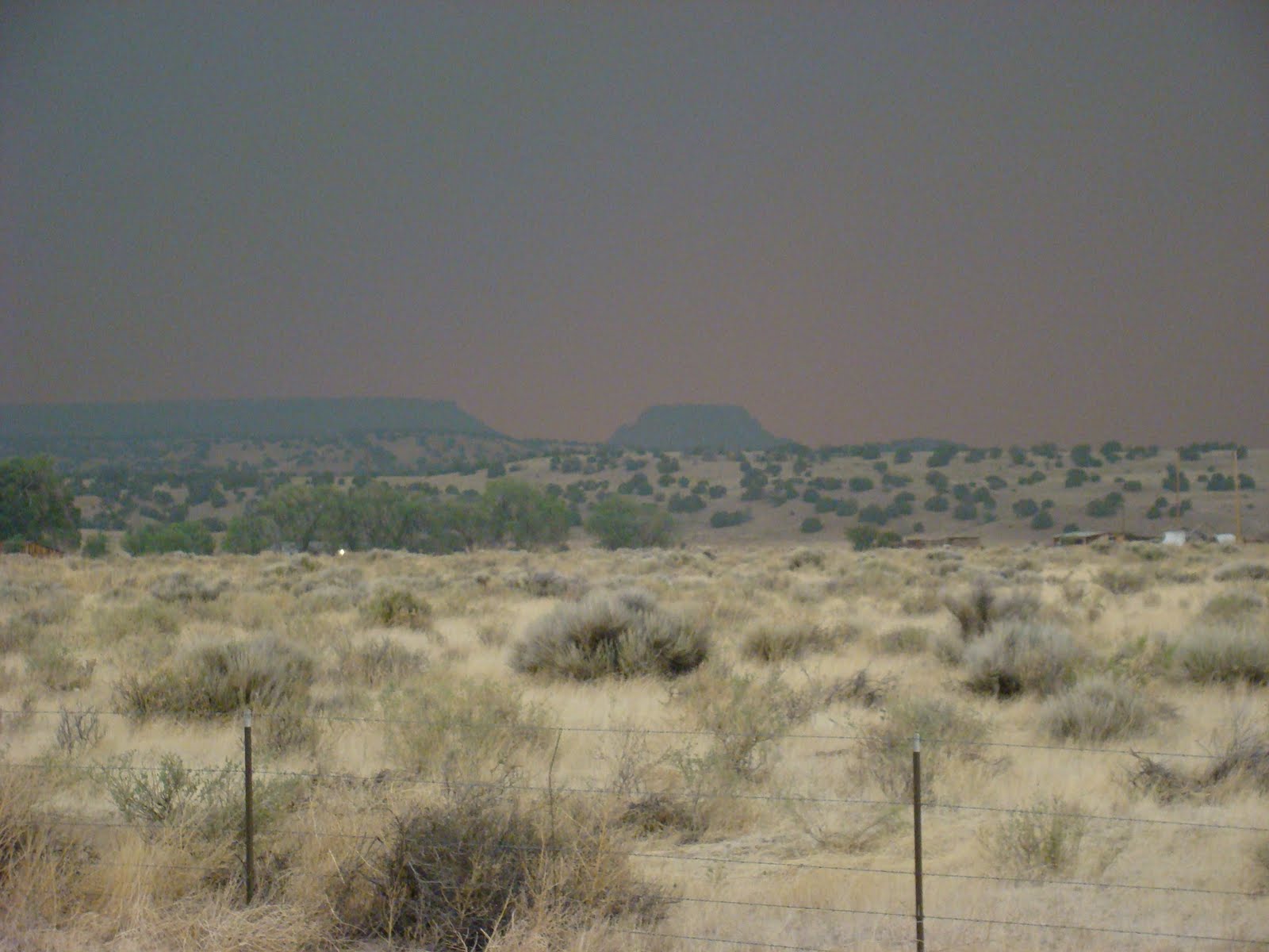 ffin Ranch on Sunday, as we watched the fire grow and grow. While I was driving back, they evacuated Alpine and Nutrioso, and dry lighting started fires in Catron County. Fire spotters were stationed along US 60, and one was on the hillside from which I took this picture, looking west through clouds of smoke and thunder toward the fire burning in Arizona. The very small shower I drove through on the Continental Divide fell with ash, making a strange gray mud on the windshield.
The fire grew by the hour and by the day. The the smoke cloud sat above the ridges on the Ragamuffin Ranch road, and it stretched from this western horizon all the way to east, a thick border of smoke dividing the sky, and headed toward the Rio Grande valley. On Monday I discovered all the best websites to get up to date news, as the fire grew into the hundreds of thousands of acres, and towns near Escudilla Mountain on the New Mexico border were evacuated.
 The animals got weary of the smoke very quickly, and even the horses, who spend snowy days out under the sky, were reluctant to come out of their stalls. Here, Rafie stands peering out with a look that says it all.
By Monday evening, there were two Type 1 Incident Command Teams in charge of nearly 1000 firefighters, and no containment. We had spent the day in a fog of smoke here at the ranch that got thicker and thicker, so that working outdoors was impossible and the gloom made us turn on the lights at 3 in the afternoon. At the community meeting that night, the residents of Eager and Springerville were told to prepare for possible evacuation, and the residents of Greer were evacuated.
 Tuesday, and there was optimism that the firefighters would hold the perimeter between Nelson Reservoir and Greer, and no further evacuations would be necessary. The CIT and I went to Quemado to get a few things at the little Country Store, and buy a cab for the '93 Dodge Ram that he is restoring to its former glory. While I sat over a cup of coffee at the Largo Cafe, talking to a trucker from Tennessee who was stranded for need of a new engine computer, we watched the smoke roll in once again. Then, as I was mopping up the last of my blueberry pie and ice cream, a couple came in and sat down to order. The woman was crying. I gave her a kleenex and she said, "Well, after all, I've never been kicked out town before." They were from Eager, and the southern part of that little Mountain town where I shop at the Merc and at Basha's was being evacuated. We stopped for the outhouse at the log yard on the way in, and ash covered the seat and the paper. The setting sun through the smoke gave the ranch an eerie, Mars-like ambiance.
Still, Tuesday night the meeting--which was streamed--was brave in the face of difficulty. We were told that they were working on holding the line at Eager, but that since Wednesday was predicted to be another Red Flag windy day, other residents of Springerville-Eager ought to be prepared.

Wednesday morning, as the sun rose through the ever-present smoke, we learned that the lines from Eager to Greer had held, but at the morning press briefing, the IC Commander said that another Red Flag windy day meant that it would be a hard day. It was, as the smoke thickened and the Mars landscape returned, we hoped for the best and began preparing for the worst. We had a phone meeting with the EG and with our partner, and the EG began driving down with the horse trailer so that we could move the horses. Thus we spent our 9th anniversary preparing to evacuate if it comes to that.By evening, the fire was now less than 25 miles away.
So Wednesday evening, when the CIT and I finished watching a movie, and just as the EG pulled up with the trailer, we turned on the computer and learned that all of Springerville and Eager were being evacuated. The Community Meeting was cancelled, and we began to plan, as we ate our dairy and fish meal for Shavuot, to evacuate the horses.
They left this morning, after we learned that the fire went through Greer and structures were lost, and that the New Mexico National Guard is at Luna, near the Arizona border and that the Quemado Volunteer Fire Department are in Coyote Canyon, waiting to engage the fire as it nears the state line.

And so I wait, while the EG and CIT drive the horses to the Rio Grande Valley, and I wonder. So far the lines at Eager and Escudilla Mountain, at Luna and at Coyote Creek are holding. Will they hold today? Tonight? Will Luna, under a pre-evacuation notice by the Catron County Sheriff since Monday, will Luna be spared? Will the fire enter New Mexico at Coyote Creek and Bonita? Will it trigger an evacuation for us in a few days? And the big question: Where will it end?
The smoke seems thinner now. Is that a harbinger of good news?