Showing posts with label On the Road. Show all posts

Saturday, August 6, 2011

Geology Road Trip Yuma: Part II

Part II: Salt River Canyon to Globe

On Sunday, August 24, I drove to Yuma to meet a friend. The trip was a wonderful drive across Geological Provinces and through various biozones, as I descended from more than 8000 feet above sea level to about 200 feet above sea level. (Yes, my ears popped, and my shampoo bottle collapsed inward). Because of areas of great geological, anthropological and historical interest, the tale of this trip is broken up into several parts. Part I--the White Mountains and the Mogollon Rim can be found here.


After leaving the Mogollon Rim and following the volcanics along Corduroy Creek, Salt River Canyon opened out shortly before reaching the Becker Butte Lookout on the north side. Traveling down the north side of the canyon is to travel downsection and down through time because the Paleozoic and Mesozoic strata dip northward, with a great deal of missing time. The caprock of Becker Butte is made up of the Devonian Martin formation, composed of the competent cliff-forming layers of limestone , with mudrocks and shales underlying the gentler, slopes on which the trees are growing. The Martin formation rests upon a sill intrusion of Devonian age. The Cambrian, Ordovician and Silurian periods are entirely missing in the canyon.

At the Becker Butte pull-out, two plaques have been erected in honor of Gustav Becker (1856 - 1940), "Pioneer, Merchant, Trailblazer and Roadbuilder--A father of US 60"; and his son, Julius Becker (1886 - 1959), "His life was based on the Principles of his Father". They were both from the first family of Springerville, Arizona, and both made their mark on the Rim Country, and are remembered for their devotion to the place.


Looking down-canyon, from a switchback on the north canyon wall, one can see back to the north rim. The inner canyon at the bottom is composed of pre-Cambrian rocks around a billion years old, that are overlain by the Paleozoic and Mesozoic sedimentary rocks. The heights are composed of the Mesozoic Red Wall Limestone which preserves at its top an ancient karst topography. It is underlain by the Martin, with its limestone cliffs and shale and mudrock slopes that fall steeply to the inner canyon and the Salt River. Upon crossing the river itself, one crosses not only from the Fort Apache--White Mountain Apache Reservation to the San Carlos Apache Reservation, but also from the Paleozoic back in time to the Middle pre-Cambrian age. The south canyon wall is composed entirely of pre-Cambrian sediments, many of them hardened by high temperatures and pressures, and metamorphosed into quartzite and marble.
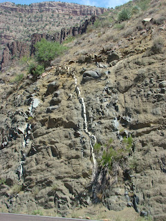


Looking upstream from Hieroglyphic Point at weathered diabase intrusion, itself intruded by lighter veins of metamorphics (including asbestos), also weathered. The diabase intrudes a middle pre-Cambrian granite, and is therefore younger, upper-middle to lower upper pre=Cambrian.

Beyond the diabase, one can see a ridge of columnar jointed quaternary basalts that are as young as the diabase is old. Beyond the basalts in the background--and across the river--are the Paleozoic and Mesozoic rocks of the north face of the canyon, showing clear stratification.

Hieroglyphic Point's name originates in petroglyphs that were pecked into the canyon wall with sharp rocks. They are the youngest features of all here, hardly varnished by the desert winds, they are a mere 1000 years old, mas or menos.


Climbing out of Salt River Canyon and moving on south toward Globe, Arizona, we enter the Tonto National forest, growing on thin soils resting on pre-Cambrian granites and quartzites also intruded by pre-Cambrian diabase. In a road cut near milepost 272 is exposed the tan and pink granite, which is deeply weathered into square blocks. Down and to the left in the picture, one can see the contact with part of a diabase sill. The sill-penetrated granite steps down southward along a series of faults that keep the highway near its surface for sometime, before the overlying upper pre-Cambrian Apache group makes its appearance in road cuts near Seven Mile Wash. The Apache group is made up of mostly unmetamorphosed sedimentary rocks upon which the road descends into the Gila River drainage and Globe.


Globe, Arizona is a gold and copper mining town that sits on the Gila Conglomerate. Globe and the mining town of Miami sit on the north end of a graben--a downfaulted area-- that extends southeast to Safford. During Pliocene time (roughly 5.2 - 1.25 years before present), the mountains rising around the graben dumped 1500+ vertical feet of their own downwasting on it. During Quaternary time, the Gila River established through drainage here, carving the terraces upon which the town of Globe is built. These terraces give Globe the steep roads that seem to rise straight up out of the Gila River valley along which US 60 runs.

It is lunchtime in Globe, 3400 feet above Sea Level, and at noon, the temperature is much warmer than it was leaving Show Low, 8000 feet at 9:30 AM. This is a good time for a break before heading through Arizona's Copper country and into the desert basins south of Phoenix.
I consider taking fewer pictures in order to get to Yuma close to when my friend's plane will arrive there. She is already landing in Phoenix, I think, which is not far away, although the winding roads in the mountains make the city seem like it must be another world.


Thursday, July 28, 2011

Geology Road Trip Yuma: Part I

Part I: The White Mountains and the Mogollon Rim

I have a young Facebook friend who has just completed her MS in Engineering and has been loo
king for the first job of her career. She got an interview in Yuma, AZ, and wanted to know if there was a way we could meet one another, since the Freedom Ridge Ranch is so close to Arizona. Although we are very close to Arizona, we are pretty far from Yuma, because it is in the far southwest corner of that state, where Arizona, California and the country of Mexico meet. Although it is a long drive, I was anxious to take a road trip, and since my friend offered to share her hotel room with me, I took her up on it.

I had a great time, and we had s
ome really good conversation because we share an interest in Objectivism, and I happen to be partial to engineers and scientists. And I got some really good Geology Road Tripping in, because the drive took me across two Geological provinces, and through several biological regions and ecotones. I drove from the Colorado Plateau where I now live and into the Basin and Range. In the process, I crossed through the short grass prairie of the east Mogollon slope, through the White Mountains of the Datil-Mogollon Volcanic field, and down through the copper and gold mining country of the Superstition mountains, and into the Sonoran Desert province, with its unique biology and weather. Over the trip I took more than 100 pictures. I geeked out so much on the landscapes and underlying geology that it will take several blogs to do the trip justice. That's what happens when I get to drive by myself!


On Sunday morning last, bags packed, I picked up my AAPG geological map, The Roadside Geology of Arizona, and I was off on an adventure. The first part of my journey took me from New Mexico into Arizona, and through the White Mountains from Springerville to Show Low, and on to Salt River Canyon. I crossed the state line on US 60, just before plunging down into Coyote Creek Canyon, the first of several canyons stepping the highway down into Round Valley and Springerville. Here a truck has just climbed up to the Arizona-New Mexico state line as I prepare to go the other way. The White Mountain volcanic field rises on the horizon ahead.


In Springerville, I turned south to stop at Safeway to get provisions, and then I continue on west on AZ 260, which will take me right through the White Mountains. West of Springerville, at South Fork, the burn scars from the wallow fire are still fresh, although the monsoons have turned the burned and blackened pastures of June into the emerald green of late July. Soon, I will leave behind the Little Colorado river valley and climb the mesa to the west, entering the high country around White Mountain Baldy.


After the climb from Round Valley and South Fork, and past the Greer turn-off ("Still Here, Still Green"), AZ 260 enters Fort Apache -White Mountain Apache Reservation, north of the Sunrise Ski area. Here, volcanic cones rise from mountain meadows. The snow fences are silent testimony to the areas of blowing snows that drift across the highway in winter.
The White Mountains consist of Tertiary and Quaternary volcanics that overlie the Colorado Plateau, forming Arizona's east-central highlands. The volcanic field has been eroded by Quaternary glaciers and their outflow, and is deeply dissected by canyons in the south, these cut by streams that are now some of finest for trout fishing in the United States.


Near McNary, 260 begins to drop just a bit, as it takes me towards the resort communities of Pinetop and Lakeside, south of Show Low. The mountain meadows and mixed conifers give way to Aspen and Ponderosa Pine. The ground here is covered in native grasses and ferns. This is a clean woods, kept so by the Fort Apache Indians, and is less susceptible to fire. The US forest service policy of no cutting and no burning, and now no grazing due to the protection of endangered species is not followed on the Res. As is true throughout the mountains, whenever one crosses a boundary between the National Forest and private and/or Indian land, the difference is immediately noticeable. Here on the White Mountain Reservation, as well as on the San Carlos Apache Reservation, we see some of the most beautiful areas in the White Mountains.

Following 260 through Pinetop-Lakeside, and then on into Show Low, where I stopped to gas up and take a short break, I rejoined US 60 and headed west. St
ill on the Colorado Plateau, here, the rocks in the shallow mountaintop road cuts are composed of the Permian Kaibab Limestone and Coconino Sandstone, which in other areas of the White Mountains are covered by the Tertiary and Quaternary volcanics. Here, on the west side of Carrizo Creek, I stopped to look back upon the White Mountains. In foreground is a layer of the older Supai Group, dating back to Pennsylvanian and early Permian time. Here, I have already descended from the Mogollon Rim, the southern edge of the Colorado Plateau, although the exact location of the contact is obscured by the volcanoes I am about to leave behind me.

The descent from the Mogollon Rim is both a physical desce
nt and a descent through time as US 60 runs down and then up, but always more down than up, through small canyons whose drainage eventually ends up in the Salt River. Here, the road cuts are composed of the Pennsylvanian and Permian rocks of the Supai Group, composed of limestones, mudstones, sandstones and conglomerates, that tell the story of a coastal area on an epicratonic sea, that rose and fell over late Paleozoic time. The descent into the Paleozoic here takes place over a few miles, as the early Pennsylvanian Naco limestone appears in the road cuts, and still further south, the Mississipian Redwall Limestone, its top surface white with the evidence of Karst topography, further down section, the Devonian Martin Formation, banded blue mudrocks between layers of brown limestones. All of these limestones tell of the depths of the sea that once covered this area, a sea teaming with strange and wonderful life.

Although by this point, the Colorado Plateau has been left behind, the descent in elevation and in time has been steady. Soon though, a dramatic plunge in the pre-Cambrian rocks of Arizona's copper and gold country will occur. Stay tuned for Part II of Road Trip Yuma.

Wednesday, June 1, 2011

Road Trip Reserve: A Geology Field Trip

Nearly Wordless Wednesday

Life is getting serious again. There are wars and rumors of wars, the economy is unstable, and some of my readers want a break from "all that." And it just so happens that last week, I took a day trip to the Catron County Seat, the town of Reserve, in order file a deed at the couthouse, on to Luna on the Arizona Border, and back through Reserve to Quemado. I drove from Quemado, and it is a spectacular drive across mountains, mesas, canyons, and two different watersheds. So, it's time for another geology road trip! Because, despite our troubles, the mountains have been standing for more than 40 million years, they are still standing, and will remain long after we--and our troubles--are gone!


Castle Rock as seen in the early morning, along New Mexico State Road 32. Like many of the mesas in the Mogollon-Datil Volcanic fields, it is a remnant of a Tertiary Conglomerate (the O.K. Bar Conglomerate) preserved by a cap of Quaternary Basalts, that has slowed its weathering. The basalts are very young, extruded less than 2 million years ago. Castle Rock is in the Apache National Forest, in the Largo Creek Wash--in the Little Colorado Watershed.


Further south on S.R. 32, the road plunges over the edge of Jewett Mesa, and into the Apache Creek Canyon. A divide had been crossed, and Apache Creek is part of the San Francisco Watershed. The water that falls on the southern reaches of Jewett Mesa flows into the San Francisco River, then into the Gila, and finally to the Colorado and the Gulf of California. The lava rocks in the center, right of the trees is made up of Tertiary Andesites that are much older than the basalts on Castle Rock. They were extruded more than 37 m.y.a.


South, after plunging into Apache Canyon, the road rides upon Tertiary-Quaternary alluvium of the Gila Conglomerates, and winds along Apache Creek into the small town of Apache Creek, at the junction of Route 32 with New Mexico 12. Apache Creek also sits at the confluence of Apache Creek with the Tularosa River, flowing southwest from its source in a small canyon on Tularosa Mountain. The camera here was pointed north across wetlands at the confluence, looking toward Jon South Mountain.


From Apache Creek, S.R. 12 winds southwest along the Tularosa to Cruzville, and then leaving the river, crosses the faults of the San Francisco Mountains, riding now on Tertiary Ash Flow Tuffs, and again on Quaternary Basalts. Here, looking west of the road across the Gila Formation, we see Mess Box Canyon, composed of a gate of Quaternary Basalts, and framed by older Tertiary Rhyolites and Andesitic domes that make up Higgins Peak and Monument Mountain.


The town of Reserve sits on a mesa at the north end of the Saliz Mountains, and in the Valley of the San Francisco River, that winds through the canyons from Arizona into Luna, and on into the Catron County Seat. Just south of Reserve, between Upper and Lower Frisco Plazas, the Tularosa River and Negrito Creek run into the San Francisco, doubling the size of the river.


After leaving Reserve, Route 12 takes a right angle west through the Five Bar Ranch, and joins US 180, which I took northwest to Luna, where I got my rifle a sling at Southwest Shooting authority. To get to Luna Valley, 180 winds across the San Francisco Mountains. Here we see the cross bedding in dune deposit sandstones that lie below the rhyolites and basalts of Prairie Point Peak. The cross-bedding in this sandstone of the Gila Group is spectacular indeed.

Following the visit to Luna, I turned back along US 180, and S.R. 12, through Reserve and back up Apache Creek Canyon, across the divide, and through Jewett Gap toward Quemado.


Noontime in the Largo Creek Wash, the dark green gymnosperms forming the side of Largo Mesa. Here, in the Little Colorado Watershed, the cottonwoods were just beginning to leaf out in a delicate green, only a few weeks past the last frost in this high Mesa and Canyon country. The waters of Largo Creek flow into the Carizzo Wash that flows just south of the Zuni Plateau, and into the Little Colorado River south of Winslow Arizona. The Little Colorado flows into the Colorado at the Grand Canyon, far north of where the Gila waters join it, near Yuma in southern Arizona, on the California border, and just north of Mexico.


Coming into Quemado from the south along S.R. 32, we cross into the more open canyon and mesa country of the Mogollon slope. Here the mesas are high, and one can see for miles. The mesas and peaks here are all part of the Datil-Mogollon volcanic field, composed of Tertiary and Quaternary volcanics, with a Chain of Craters that march north and east, from the Red Hill near the Arizona border to Mount Taylor. The youngest of the lavas are less than 2,000 years old north in the Malpais. The earth is still very active in this part of New Mexico.

Ragamuffin Ranch lies in this open mesa and canyon country, the canyons created by ephemeral washes that lie above shallow aquifers, creating little areas where the grass is good, and the volcanic sediments create a fertile soil watered by wells pumped by windmills.

Monday, January 31, 2011

Good Weather for a Road Trip


Since January 1, 2011, the Engineering Geek and I have spent exactly three nights under the same roof. All of those nights were within the first two weeks of January. On New Year's Day, the CIT and I drove down through frigid sunshine on icy roads because he was due to start school on the 3rd. At that time, Cowboy J. and his wife Nurse A. were still living in the ranch house, and the CIT and I took up housekeeping in the Cabin. However, they have since moved to new digs, and we have one horse, three pregnant cows, two heifers, and one bull to care for, as well as the dogs. So as one of us stays at Ragamuffin House to prepare our move, the other is down here, looking after the CIT and Ragamuffin Ranch.

One of the few consolations for our hurried lunches at halfway points between the two places is that the weather had been good for roadtrips over the past month. Last Monday was one of the best days. The roads were completely dry, the sun was out and the temperature was in the 40's in the highlands and in the 50's in the Rio Grande Valley. And I was driving US 60 to Socorro and then up I-25 to Belen, where I was planning to meet the EG for lunch, so that we did not have to pass exactly like ships in the night. I took some good pictures of the geological features that day, for the sun was out and despite a stiff wind in the valley, the air was relatively clear. Here, then, are some pictures of the grandeur of New Mexico.


Peaks of the Sawtooth Mountains near Pie Town, NM, rise above the surface in these southern reaches of the Colorado Plateau. The Sawtooths are part of the Mogollon-Datil Volcanic Field, and are the sedimentary deposition of pyroclastics weathered from the volcanic action between 24 and 40 million years ago. The sedimentary layers also include breccias composed of large pieces of the country rock at the time, limestones and sandstones that were incorporated by the streams that deposited the weathered volcanics.

Looking southwest across the plains of San Augustin towards the San Mateo Mountains west of Magdalena. During the last ice age, a glacial lake resided within the downfaulted block between two upfaulted mountain ranges. The lake within this graben finally disappeared about 8,000 years ago. I was standing on an old beach bar of the lake that once was. The San Mateos are volcanic in nature, and the rock is composed of ash flow tuff and rhyolite flows that erupted during the Oligocene, about 28 million years ago. I find it easy to imagine the waters of a lake on the flat plain below the mountains.


The western front of the northern Magdalena Mountains, here seen from just west of Magdalena, NM. The mountains core consists of Precambrian igneous and sedimentary rocks that were upfaulted relative to the Precambrian sediments I was standing above while taking the picture. These mountains were later intruded and extruded by basalts and volcanics of the same age as the Rocky Mountains to the north, during the Laramide Revolution about 65 million years ago. These events account for the minerals , including silver and iron ore mined at Magdalena and Kelly during the early years of the 20th century. Highway 60 here joins a fault that defines the edge of the mountain range.


Looking slightly north of east across the Rio Grande Rift west of Magdalena. Behind me is the Magdalena fault that is resposible for the high valley upon which I stand. Across the rift are the upfaulted Los Pinos Mountains that define the eastern edge of the rift. The rift defines an area where the continent is being stretched apart, and the fault blocks on either side bound a graben. These faults are still active and the mountains are still rising relative to the valley floor. The Rio Grande Rift began pulling apart nearly 30 million years ago, and the maximum distance between Pennsylvanian Limestone at the top of the fault-block mountains and that same formation below the valley sediments is as much as 30,000 feet. The rifting is responsible for the activity of the Mogollon-Datil Volcanic Field to the west.


Here I am standing on the stabilized dunes of the Rio Salado north of Lemitar, within the Rio Grande Rift itself. The mountains in the background are rift fault block above the dunes to the southwest. They are composed of tertiary sedimentary rocks rising from the quaternary Santa Fe Formation. In the foreground, is a moving dune field just across the Rio Salado.


Here, I am standing on a terrace of the Santa Fe Group west of the Rio Grande at Belen looking across the rift to the Manzano Mountains that here define the Eastern boundary of the Rift. The steep side of the fault block, these mountains rise steeply, and form a rainshadow over the valley. The "green side" is the other side, that falls to the hinge of the fault block at a much gentler angle, and catches the rainfall.

The EG and I met and ate at a little railway car diner there on the edge of the terrace, that is open 24 hours a day. I recommend the Green Chile Burger.My trip took me on up the Rio Grande Rift to Albuquerque and then through the pass made by the Tijeras Fault to Ragamuffin House.

I thought I would be making another road trip from the Ragamuffin Ranch to Ragamuffin House this week, but the January thaw seems to have ended with the month, and today snow showers have become a steady snowfall here in the Western Mountains. It looks like I am here for the week, as the Continental Divide is expected to be difficult traveling. So I will look back with pleasure at the good weather and the road trip while I contemplate taking the 4WD ranch truck to the bus stop this afternoon to pick up the CIT.

We do need the snow. But the bitter cold that will follow, I could do without.


Monday, February 22, 2010

Another Road Trip: Socorro and Catron County


NEARLY WORDLESS SPECIAL


Before the big snowstorm hit last night, Flat Ryan and I went with the Professional Revolutionary and another friend, to Socorro and Catron Counties in west-central New Mexico to hike around some different properties the friend was looking at. It was a great opportunity for a roadtrip before the snow began.


The Ladron fault block, topped with snow, can be seen behind the the stabilized dune field at the confluence of the Rio Puerco and the Rio Grande.


A wilderness area in the Barrel Hills in northern Socorro County, outside of Magadalena, NM.
There was much evidence of volcanism in the rocks, including a brecciated welded tuff in the small arroyo in the center of the picture. We hiked the arroyo, a warm microclime on a windy day.


A spring, a small source of water, at the base of the bank of the arroyo. The water accounts for the presence of willow growing in abundance in an otherwise desert plant ecosystem. The welded tuff forms the bank, and brecciated volcanics form the darker rock at the top.


We stopped at the rest stop on US 60 so that Flat Ryan could get his picture taken in front of the Very Large Array. He's blurred because of the strong wind and the distant camera focus. Behind him is the old San Augustin glacial lakebed, with the VLA buildings and two radio antenna's in the mid foreground. The lakebed appears to run all the way to the San Mateo Mountains.


Clouds build over the ridges of the San Mateo Mts. above Highway 12 at Datil, NM. They are harbingers of the oncoming snowstorm that hit the state today.

After getting stuck in the mud at a property southwest of Datil, we drove back across to Socorro and dinner, then home.

A good day. Wonderful company and interesting geology.

I think I want to live in Catron County.


Sunday, February 14, 2010

February Roadtrip: Roundtrip Alamogordo

NEARLY WORDLESS SPECIAL


It has been a record winter here in central New Mexico for snow and cold. El Nino has prepared us for a mild fire season this coming spring and summer. But in the meantime, a three day weekend, and a visit by Sheriff Richard Mack to Alamogordo's 2nd Amendment Task Force made it impossible to resist an overnight road trip to the warm southern part of the state.


Accompanying me and the Engineering Geek south were my business partner, the Professional Revolutionary, and Flat Ryan, who had arrived by mail from Atlanta. Flat Ryan is here to learn the geography and culture of New Mexico for a few months in order to teach his three-dimensional avatar upon his return to Geogia. He appears in two of the pictures below.


We took the 40 east to Moriarty, and then drove south through Estancia to Willard, where we cut southeast through Cedarvale to Corona.

Shortly after leaving Willard, we encountered a windfarm perched on the northeastern edge of the magnificent Chupadera Mesa. Below the very space-age looking electricity-generating windmills, was an old fashioned windmill used to pump water for cattle.

In the lobby of the Flickinger Theatre in
Alamogordo, Sheriff Richard Mack poses
with Flat Ryan before giving his speech on
based on his book by the same title.


Sheriff Mack, of Graham County, Arizona,
was one of two plantiffs for the Printz-Mack
that reaffirmed that the County Sheriff is
the highest officer in his county, and has the
responsibility to protect his people against coercion by federal agents of any kind.


After the event, we went to a Patriot Alliance Reception sponsored by Alamagordo 2ATF, the Lea County Tea
Party Patriots, and our own New Mexico Patriot Alliance.


It was very nice down south, with temperatures in the 50's and 60's during the day, with a gentle southeastern breeze.
Allof my long sleeved clothes seemed suddenly too warm, and I put the winter coat in the trunk, using only a hoodie at night. Wonderful!


align="left">But Sierra Blanca had more snow on it than I had ever seen, reminding us that this very cold, wet winter is not yet complete. So we stopped near Oscura to take pictures near an old railroad trestle that spanned one of the Three Rivers.
Spectacular!


After stopping in Carrizozo for a cold Cherry Cider,
we cut across Chupadera Mesa on NM 55, instead
of going around it through Corona and Cedervale.


We stopped in Claunch, where the Library doubles as
the Post Office, and then took Flat Ryan on a short
tour of the Gran Quivera site of the Salinas
posing in front of a pair of manos and matates,
used by the native women for grinding maize.


From GQ through Mountainair, and then the last leg of the trip home, along the Manzano Mountains. Here, we stopped near Toreon to get a rare picture of the entirel Estancia Basin covered with snow. In the distance (middle right), blow-out dunes outline the form of a beach berm, formed when Glacial Lake Estancia filled this basin up to 7000 years b.p.


Years ago, I worked on the Glacial Lake Estancia project, identifying microfossils--ostracods--that grew in that lake. By looking at the relative numbers of various species, we could tell when the lake was rising and when it was receding.


The snow in the picture, beautiful as it is, indicated to us that we had returned to the frozen north! Thank goodness, no more snow is predicted until later in the week.


Wednesday, November 11, 2009

Going to Continental Congress: Sedillo to St. Charles

NEARLY WORDLESS WEDNESDAY
On Monday, New Mexico Delegate Michael Lunnon and I began the drive from Gallup (in Michael's case) to St. Charles. Michael stopped to get me on a warm and sunny Sedillo fall morning, the kind with the New Mexico blue sky that breaks the heart. We drove 14 hours on Monday, finally stopping in Springfield, Missouri just past midnight Tuesday morning. Yesterday, we drive about eight hours from Springfield, MO to St. Charles, Illinois.
But I still had time to take a few pictures . . .


Looking north just east of Milagro, NM.

Pinyon-juniper woodlands and shortgrass prairie, near the ecotone where, as we descend east, the trees will give way to the grasslands.


At the rest stop west of Santa Rosa, NM, a red-rock canyon composed of brilliant shales, as we descend into the Pecos River Valley.

Rio Grande Valley. Pecos Valley. Later the Canadian. As we go eastward, each river valley will be lower by thousands of feet than the last, as we drive down the incline of the alluvium from the Rockies and Basin and Range.


Grain elevator east of Amarillo on the Texas Panhandle.
We had driven into a frontal system, clouds and fog.


Texas Panhandle, just west of Oklahoma. It seems as flat and level as a table top, and it is indeed one massive mesa. But the slight incline away from the mountains to the west is not perceptible, although it is there. It is the alluvium and wind-blown detritis of the Rockies, fingers of which reach all the way to the Mississippi River.


We drove into the night in Oklahoma, talking and talking, learning to understand each other with respect to all of the issues that will be argued at the Continental Congress. We found ourselves to be sympatico.


In the morning, a water tower in Rolla, Missouri, on the east slopes of the Ozark Dome. Hardwood forests in these low, very old mountains: Maple, Walnut, Oak.


Bare tree on a hilltop west of St. Louis, where the Ozarks are interrupted by the Mississippi River.

They continue into Southern Illinois more weathered still at the edge of the dome; and in Kentucky and Tennessee, meeting the the Appalachians.


Across the 'Father of Waters' (not pictured--we could not pull over), in the coal and oil country of Southern Illinios, we stopped.

The flag is at half-staff to honor the fallen soldiers murdered in Texas. Tomorrow, on Veterans Day, we will renew our oaths to protect and defend the Constitution of the United States.


Woods and pond at a rest stop south of Springfield, Illinois. The clouds were closing in, and we drove through intermittent, heavy rain until it cleared from the west near Joliet, Illinois.

Every time I make this drive, I think about the vastness and diversity of the United States and the uniqueness of the North American Continent.

Stretching from Atlantic to Pacific, the geographic and geological diversity is stunning, as is the regional diversity of the people. An amazing place.

And a fitting way to enter into the frame of mind needed to do our part to restore the Constitution that creates out of that diversity fifty sovereign states, which together create these United States.

E Pluribus Unum. Out of many, one.


Thursday, February 21, 2008

Road Trip: Gran Quivera

Tuesday was the last day of a long weekend for N.'s friend, A., and the forcast was for a warm but cloudy day. It is February, that time when winter seems to be hanging on forever, and the routine begins to feel unbearable.

It was, in short, a perfect day for a road trip. So we picked A. up at home in the morning and stopped at Smith's in Edgewood for some junk food. That's right, what's a road trip without junk food?

And it was off to the south for a Visit to the Salinas Pueblo Missions National Monument--Gran Quivira Unit--about 70 miles south of Tijeras. Gran Quivira is the most southeastward set of ruins of three Indian villages that comprised the Salinas District of the Spanish Colonial Missions. The Tompiro speaking natives of this village had traded salt from ephemeral lakes left behind when Glacial Lake Estancia dried up about 7000 years ago. They had first come to Chupadera Mesa (south of Mountain Air, NM) between 1200 and 1400 CE, and were then made a Spanish possession in the late 1500's. The first mission church was built in 1630.

This picture, looking south from the village ruins, is of the ruins of the first church (built 1630) right next to a ceremonial kiva, the center of the Puebloan religion. The boys commented on how odd it must have seemed to the Tompiro natives, to build such a large structure for two men with no wives or families, when the Puebloans, far more numerous, worshipped in the intimate spaces of an underground kiva, and lived in small 'apartment' rooms in the pueblo.

This is the nave of the larger church, built with an attached "convento" in 1670. This church is set apart from the pueblo village, and a little to the northwest, whereas the first church was located right next to one of the larger ceremonial kivas near the village center.

By this time, Gran Quivira was an important trading center for the Spanish, salt being an especially valuable commodity. It was also a jumping off point to trade with the native people of the plains to the east, although missions did not get built among those people, as they were not settled and were also quite fierce in defending their territories.


Here are some of the ruins of the Tompiro speaking pueblo, Cueloze, taken from the partially excavated upper village. The boys had a great deal of fun on the upper village, following the maze of walls so that they might identify kivas hidden beneath the peublo 'apartments'. Although the Fransciscan missionaries had tolerated the larger, open kivas and their ceremonies to begin with, they soon forbade the "pagan" rituals practiced there, and the Tompiro who had not joined the new church were forced to hide the practice of their own religion. In 1601, one Marcello de Espinosa wrote:
"There is a sweat room (kiva) painted all over with large and small idols in the same manner that they paint devils here. In the middle are sculpted large idols of stone or wood to which they offer maize...and when they make a 'sacrifice' they all join in a circle to dance..."

The boys asked many questions about theway that the conquering Spaniards forced their religion on the natives, and were quite interested in learning that many of the Pueblo Indians identify as Christians to this day. They speculated about how that compared to the way that near-eastern religions were spread by conquest, and also Christianity to Europe, and Islam to North Africa and Asia. They drew parallels between the hidden kivas, and the conversos, the hidden Jews of northern New Mexico, some of whom retain their hidden Jewish practice to this day. They were very happy to discover that the Katchina dances of the nineteen Pueblos of the Rio Grande are the religion of the Puebloan peoples, practiced to this day.


These are the steps of the convento, leading up from the south courtyard and gardens to the common areas and cells. The boys were also fascinated by the windows, which had very thick walls that slanted inward, to make shadows so that the summer sun would not overheat the rooms inside.
N. also pointed out that the shape would work well for defense, with two bowmen able to creat crossfire from either side of the window, and yet remain hidden by the angled walls.

I am often taken aback at how much they have learned about history, about religion, and about warfare without me being much aware of it. In visits to many historical sites in New Mexico, they have learned that the Puebloans, and later the Spanish and then the Americans, had to always be aware of the raiding Apachu--a Tewa word for enemy or thief--the fierce Apache, Athabaskan speakers who hunted the plains and raided the stores of the settled peoples.

It was indeed a beautiful day for a road trip,
and at Gran Quivira it was 60 degrees.

Although partly cloudy, the sun did shine on Chupadera Mesa, as we stood above the newly built ramp to spot golden eagles hunting the vally and hills between. We tried to imagine what it must have been like to be the Tompiro people, meeting the Spaniards for the first time.

And what it must have been like to be a Spanish mission priest, out here on the edge of the empire, sitting outside the church on a February day, watching the eagles hunting from the top of the Mesa.

And so our road trip, undertaken to break the monotony of blustery February, became a field trip, a chance to delve into New Mexico history, and to think about issues of colonization, economics, warefare, and religion.

As N put it: "History. It's everywhere you want to be."

Sunday, August 26, 2007

Travelogue Last: Home At Last!


Sunday, August 19, 2007

Morning in Needles, California: Time= 7 A.M. Temperature = 98 degrees F. We can hardly wait to get out of this place and start driving east--and up onto the Colorado Plateau.

Needles lies in the Colorado River Valley, between fault block ranges of the Basin and Range Province. The elevation is low, and the landscape is of the Mojave Desert. Hot. Dry. Barren.

After a good breakfast at a local chain next to the motel, we loaded Henry up. By 8:30 the temperature was 100 degrees (F) and the heat was ennervating.


It was my day to drive again. We had been on the road less than an hour, when the coffee I had consumed at breakfast made a quick stop at a Rest Area west of Kingman vital. I took a picture of the landscape at the Rest Area--still Mojave Desert index plants. This is a Palo Verde plant against the mountains. The temperature here was 101 degrees (F).

And then another stop at Kingman, Arizona, to load up with gas. The prices in Needles were the highest we had seen anywhere. The gas prices in Kingman were more toward the average, and nearly a dollar lower than Needles. I am glad we were able to make Kingman for the gas. The people in Needles are being gouged.


From Kingman, Arizona, we ascended up onto the Colorado Plateau in a series of long hills, and then onto the San Francisco Volcanic Field, dominated by San Francisco Peak, the highest mountain in Arizona.

At about 11:30 MST (Arizona does not observe daylight time), we stopped at a rest stop just west of Flagstaff, which sits just below San Francisco Peak. What a difference in landscape and temperature. We had come quite high, and the landscape was Ponderosa Pine Forest. The temperature was 86 degrees (F). We lingered there, taking pictures of a volcanic cone that was being mined for aggregate.


From Flagstaff, we came down off the San Francisco Volcanics and into the Painted Desert. This area is in an old lake bed, and there are two national parks--Painted Desert and the Petrified Forest. The painted desert is called that because of the colors of the sediments from the weathering of certain Colorado Plateau formations.

Here we took a quick stop near the turn-off the Meteor Crater to take this picture. We got right back on I-40. Meteor Crater is a fun stop, but we were eager to get home after 10 days of traveling!


At about 3 PM MDT, we crossed the border into New Mexico! Even though we still had a long drive ahead, seeing the welcome sign made us feel like we had arrived. And just about at the border, the lake sediments landscape gives way to the Mesas and valleys of the Colorado Plateau formations. Coming into New Mexico from the west, you can really see a change!

We had planned to stop at the Welcome Center rest area and eat a late picnic lunch (our body-clocks were set to PDT), but the center was closed for rennovations. So we happily stopped at Blake's Lot-a-Burger in Gallup, and got our first Green Chile Burgers since we had left home. Green Chile--the state fruit of New Mexico--which leads to the official state question: Red or green? Green chile is addictive and New Mexicans long for it when traveling out of state.


Then it was time to get some gas and hit the road for the last leg of the journey. Bruce and N. both napped as we already had the Roadside Geology for this stretch of I-40 pretty well memorized. I tuned the radio to the Oldies Station broadcasting from Cortez, Colorado, and headed east. We traversed the northern part of the Malpais Volcanics (some flows are less than 1,000 years old) and then through the Mesas near Acoma Pueblo. At the top of Nine Mile Hill, we left the Colorado Plateau behind to descend into the Rio Grande River Valley and into Albuquerque. The Sandia Mountain Fault Block--our beloved and familiar mountains--can be seen rising above the city and the river in the distance from the top of Nine Mile Hill. Bruce woke just in time to take some pictures.
We drove down across the Rio Grande, then ascended to the foothills of the Sandias. Then into Tijeras canyon and along the creek that runs down Tijeras fault, up to Zuxax and then up Sedillo Hill to our road and home!

It was a good trip. And a wonderful homecoming.

And it's great to finish the travelogue, so that I can have my mind squarely in the present!