


Part I: The White Mountains and the Mogollon Rim
I have a young Facebook friend who has just completed her MS in Engineering and has been looking for the first job of her career. She got an interview in Yuma, AZ, and wanted to know if there was a way we could meet one another, since the Freedom Ridge Ranch is so close to Arizona. Although we are very close to Arizona, we are pretty far from Yuma, because it is in the far southwest corner of that state, where Arizona, California and the country of Mexico meet. Although it is a long drive, I was anxious to take a road trip, and since my friend offered to share her hotel room with me, I took her up on it.
I had a great time, and we had some really good conversation because we share an interest in Objectivism, and I happen to be partial to engineers and scientists. And I got some really good Geology Road Tripping in, because the drive took me across two Geological provinces, and through several biological regions and ecotones. I drove from the Colorado Plateau where I now live and into the Basin and Range. In the process, I crossed through the short grass prairie of the east Mogollon slope, through the White Mountains of the Datil-Mogollon Volcanic field, and down through the copper and gold mining country of the Superstition mountains, and into the Sonoran Desert province, with its unique biology and weather. Over the trip I took more than 100 pictures. I geeked out so much on the landscapes and underlying geology that it will take several blogs to do the trip justice. That's what happens when I get to drive by myself!
On Sunday morning last, bags packed, I pi
 cked up my AAPG geological map, The Roadside Geology of Arizona, and I was off on an adventure. The first part of my journey took me from New Mexico into Arizona, and through the White Mountains from Springerville to Show Low, and on to Salt River Canyon. I crossed the state line on US 60, just before plunging down into Coyote Creek Canyon, the first of several canyons stepping the highway down into Round Valley and Springerville. Here a truck has just climbed up to the Arizona-New Mexico state line as I prepare to go the other way. The White Mountain volcanic field rises on the horizon ahead.
In Springerville, I turned south to stop at Safeway to get provisions, and then I continue on west on AZ 260, which will take me right through the White Mountains. West of Springerville, at South Fork, the burn scars from the wallow fire are still fresh, although the monsoons have turned the burned and blackened pastures of June into the emerald green of late July. Soon, I will leave behind the Little Colorado river valley and climb the mesa to the west, entering the high country around White Mountain Baldy.
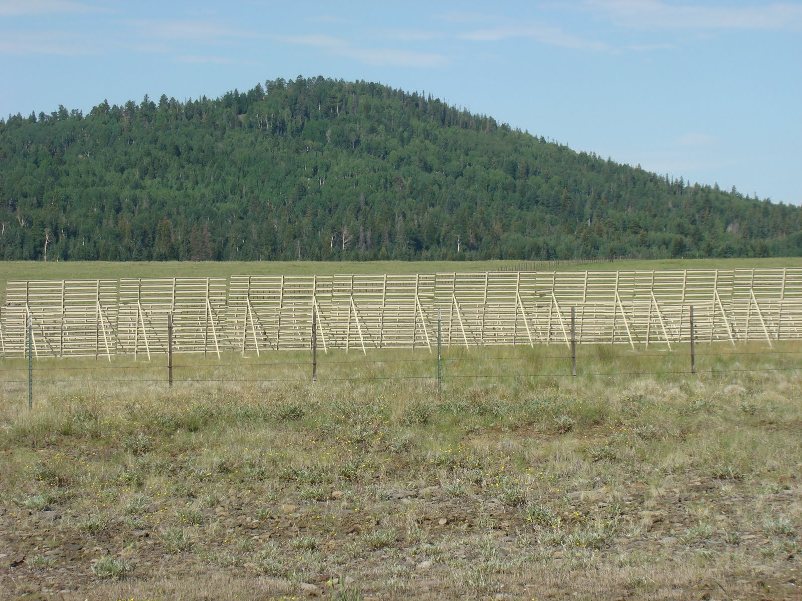 After the climb from Round Valley and South Fork, and past the Greer turn-off ("Still Here, Still Green"), AZ 260 enters Fort Apache -White Mountain Apache Reservation, north of the Sunrise Ski area. Here, volcanic cones rise from mountain meadows. The snow fences are silent testimony to the areas of blowing snows that drift across the highway in winter.
The White Mountains consist of Tertiary and Quaternary volcanics that overlie the Colorado Plateau, forming Arizona's east-central highlands. The volcanic field has been eroded by Quaternary glaciers and their outflow, and is deeply dissected by canyons in the south, these cut by streams that are now some of finest for trout fishing in the United States.

Near McNary, 260 begins to drop just a bit, as it takes me towards the resort communities of Pinetop and Lakeside, south of Show Low. The mountain meadows and mixed conifers give way to Aspen and Ponderosa Pine. The ground here is covered in native grasses and ferns. This is a clean woods, kept so by the Fort Apache Indians, and is less susceptible to fire. The US forest service policy of no cutting and no burning, and now no grazing due to the protection of endangered species is not followed on the Res. As is true throughout the mountains, whenever one crosses a boundary between the National Forest and private and/or Indian land, the difference is immediately noticeable. Here on the White Mountain Reservation, as well as on the San Carlos Apache Reservation, we see some of the most beautiful areas in the White Mountains.
Following 260 through Pinetop-Lakeside, and then on into Show Low, where I stopped to gas up and take a short break, I rejoined US 60 and headed west. Still on the Colorado Plateau, here, the rocks in the shall
 ow mountaintop road cuts are composed of the Permian Kaibab Limestone and Coconino Sandstone, which in other areas of the White Mountains are covered by the Tertiary and Quaternary volcanics. Here, on the west side of Carrizo Creek, I stopped to look back upon the White Mountains. In foreground is a layer of the older Supai Group, dating back to Pennsylvanian and early Permian time. Here, I have already descended from the Mogollon Rim, the southern edge of the Colorado Plateau, although the exact location of the contact is obscured by the volcanoes I am about to leave behind me.
The descent from the Mogollon Rim is both a physical descent and a descent through
 time as US 60 runs down and then up, but always more down than up, through small canyons whose drainage eventually ends up in the Salt River. Here, the road cuts are composed of the Pennsylvanian and Permian rocks of the Supai Group, composed of limestones, mudstones, sandstones and conglomerates, that tell the story of a coastal area on an epicratonic sea, that rose and fell over late Paleozoic time. The descent into the Paleozoic here takes place over a few miles, as the early Pennsylvanian Naco limestone appears in the road cuts, and still further south, the Mississipian Redwall Limestone, its top surface white with the evidence of Karst topography, further down section, the Devonian Martin Formation, banded blue mudrocks between layers of brown limestones. All of these limestones tell of the depths of the sea that once covered this area, a sea teaming with strange and wonderful life.
Although by this point, the Colorado Plateau has been left behind, the descent in elevation and in time has been steady. Soon though, a dramatic plunge in the pre-Cambrian rocks of Arizona's copper and gold country will occur. Stay tuned for Part II of Road Trip Yuma.


2 comments:
Good to hear from you again!
I enjoy the geology information and the pictures, and am looking forward to subsequent Parts. Thank you.
fwiw, Leon County, Florida (Tallahassee) has the Red Hills in the North and Karst with dolines (sinkholes) in the South; I live within easy walking distance north of the Cody Escarpment:.
http://publicfiles.dep.state.fl.us/FGS/FGS_Publications/FGS%20Library%20Documents/Cody%20Scarp%20Upchurch.pdf
Quite glad you're still there and maybe still green.
-lesle
(I think I mentioned it before, but my google account is bollixed in that if I use it when making a comment, the comment is not accepted and I can never come back and comment on that post....so it's anon for me.)
Lesle--would it be possible to geet pictures of the Red Hills and the Karst topography? Those are extant landscapes of what the rocks out here are showing us. The present is the key to the past!
By the way, now that the monsoons are in their full glory--we are getting rain everyday and sometimes more than once in the day--it is greening up nicely! Great to hear from you again!
Post a Comment