On the road at 6:09 AM. I drove, radio tuned to NPR for a rare listen to Morning Edition. ABQ traffic heavy but normal. We took I-40 west to I-25 north. Off at Bernalillo on 550 north to the Four Corners region.
We drove through Bernalillo. Lots of development there. Talked about how Starbucks is taking over the world. "If you want to take over a country, you have to establish a presence," said N.
The road curves up to the north and then to west across the badlands around the Rio Puerco. White Mesa to the south at Zia Pueblo, home of the type specimen for a small purple daisy, Erigeron gypsophilia, an endangered flower first identified by Tim Lowery at UNM while I was his student. N. was fascinated by the idea of a flower that could live on gypsum. We talked about how adaptation works.
Up, up, up onto the Colorado Plateau. We seem to be driving up the edge of the earth. Past the purple, pinks and greens of the Jurassic Morrison Formation, the base of the Plateau here in NM. Up, up, up, finally driving on the red shales below the the towering cliffs of the Dakota Sandstone near Cuba. Then over the continental divide and into the Farmington Basin. Here we are driving past the uncomformity between the Cretaceous rocks and the younger Kirtland formation--coal and oil bearing sands and shales. We stop in Farmington for the bathroom and a snack. Lots of oil and gas company vehicles in the gas station parking lot and on the streets. Bloomfield, Farmington and Aztec have the boom and bust look of oil towns. We talk about the economic geology of oil production and distribution.
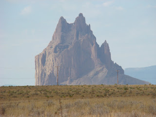
 On the way to Four Corners we pass by Shiprock, a diatreme that is sacred to the Navajo. A diatreme is the frozen neck of a volcano exposed due to weathing of the cone around it over time.
 We have traveled up through time this morning, from the rocks of the early Mesozoic period about three hundred million years ago through to the earliest Cretaceous. The volcanics are younger still, coming from activity as recent as a few thousand years ago as the continent stretches and thins in the Rio Grande Rift--and area where the continent is drifting apart due to differential movement on either side of the rift.

Four Corners, New Mexico-Arizona-Utah-Colorado. After taking a turn standing with one foot over the four corners, thus briefly residing in four states at once, we had lunch at 12:30 PM. Or was it 11:30 AM? Although all four states are in the Mountain Time Zone, Arizona does not follow Daylight Savings Time. So we gained an hour whenever we went into Arizona. All of this about boundaries provoked the following thoughts from N:
"The land over there in Utah and Colorado and New Mexico--it is all the same as the land here in Arizona where we are sitting to eat lunch. The rock formations are the same. And the sun is about at local noon. The boundaries--they are not really real.They are made by people. I guess they are made for reasons, but the land itself--it does not have these reasons. The state boundaries are for governments, right? It's so that people know who to pay taxes to and what sheriff to call? The time one--that's different. It is kind of real. Because the earth turns--it turns and that takes time--24 hours. So the dawn comes later in the west (of the US) than the east...but where exactly to put the difference? I guess that the railroads decided that. The actual place is not important...it's...it's ..."
"Abitrary," said Bruce. And that started a discussion of arbitrary that lasted well into Utah.
In the afternoon, we drove up through more of the Colorado Plateau in Utah. The route we took did not go through Monument Valley, but we could see the castle-like buttes and mesas away to the south as we drove across the Morrison formation near Bluff. There we climbed up onto the Bluff sandstone, which has it's type-section there in bluff--for which it is named.
From Bluff Utah to Blanding, we played peek-a-boo with the colorful Morrison and the overlying sandstones as the road came up and down into canyons formed by the rivers in the Dakota Sandstone. After Monticello, Utah, things got really interesting as the Entrada formation appeared. The Entrada is a resistant, colorful rock underlaid by a muddy shale that erodes easily, so there are formations like church rock.

Approaching Arches National Monument, things got really interesting as we entered the La Sal Anticlinal Valley, and later the Spanish Trail Anticlinal Valley. What happened in these places is that salt, which flows under pressure, was pushed in between the rock units with the Entrada on top. The salt formed an arch, which made the rocks above fold over it into an anticline. Then the salt was dissolved out by water and the anticline collapsed making a valley with the oldest rocks visible in the middle and the youngest on the edges. The Entrada formation has two members that weather differently and viola! You get arches, like this picture of Window Rock.

We took a rest stop in Moab and loaded up with gas, having come nearly 400 miles from Albuquerque. At Moab, we crossed the Colorado river, where we stopped to put our feet in the water and get a little muddy.
N. was feeling anxious to continue driving and at the same time, he wanted to stop at the river. But he did go down to get his picture taken there. The last time I stopped there, in 1999, the river was low and relatively clear. This time it was high and fast and carried a lot of the sediments that give it the colors for which it was named.
Then we drove past the actual entrance to arches, and began to climb out of the anticlinal valley toward I-70.
At this point we began driving out of the Colorado Plateau highlands toward the Wasatch front. In the process, we crossed the beatiful Green River (of Flaming Gorge fame) at the town of Green River, and then up across the San Rafael Swell, a structural feature similar to an anticline, but with a gentle slope on one side and a steep on on the other. The San Rafael Swell gives a wonderful view of the Cretaceous in Utah. The towering dune sandstones of the Navajo and Wingate sandstones, both deposited by wind, show sweeping cross-bedding. Further, we crossed into the earliest Paleocene (Cenezoic rocks), and saw the contact that identifies the unconformity between the two eras. It is more visible in the four corners, though, where you can put your finger across the period of the extinction of the dinosaurs 65 million years ago. The picture above is of Castle Valley seen from the crest of the San Rafael Swell.

Shabbat dinner of cold chicken and bread and wine under the stars completed our day. A needed oasis appeared in the desert after 550 miles of driving!

Oops! I downloaded another picture of Four Corners. Same as the first picture, too. And in real time we are in Susanville and we need to get going if we are to reach the coast today! We have to pick N. up by Noon tomorrow, PDT. And we need to stop at Lassen County Courthouse to get information about our land here. So...you get another picture! I don't have time to figure out how to delete it.
One of these days, I'll learn to really use Blogger.
Published from Susanville, CA


3 comments:
It looks like you're having a terrific trip.
Great to see pix...I've missed your blog! :) I love shiprock - I was always amazed by that blurry heat horizon waviness that made it look as if it were floating above the ground, ready to take off at any moment.
Glad to know that all is well and that you guys are having an educational journey - I'm having a terrific educational experience in reading about your travels.
Post a Comment